Ground segment
Also known as Ground station, Mission operations, SatNOGS, Ground network
The stations, networks, software and people that talk to a satellite. Small missions combine their own station with open networks such as SatNOGS; a mid-latitude station sees a 525 km Sun-synchronous orbit about three times a day above 10°.
- Document
- SQ-OP-002
- Updated
- Reading time
- 5 min
In this tab
Definition
The ground segment is everything on Earth that operates a spacecraft: antennas and radios, the network that links them, the software that plans passes, decodes frames and archives telemetry, and the operators. For a small mission it is often the part the team underestimates, although every byte of the mission passes through it.
Stations and networks
A typical amateur-band station for a UHF PocketQube combines a crossed-Yagi antenna on an azimuth–elevation rotator, a low-noise amplifier (LNA) at the mast, a software-defined radio and a computer that steers the antenna from current orbital elements and tunes the receiver for . Omnidirectional antennas such as quadrifilar helices or turnstiles need no rotator but give up about 11 dB of gain.
No single station sees a low-orbit satellite for long, so missions in amateur bands rely on networks. , the Satellite Networked Open Ground Station project of the Libre Space Foundation, links hundreds of volunteer stations through an open scheduler and database[1]. For every observation it archives a waterfall image of the received spectrum, an audio recording, demodulated frames and, where a decoder exists, decoded telemetry[2]. Open demodulators such as gr-satellites[3] and declarative decoders written in Kaitai Struct[4] let anyone turn those recordings into data.
The Grizu-263A ground segment
Grizu-263A was operated from the ZBEÜ station at Zonguldak Bülent Ecevit University, SatNOGS station 1184 (Maidenhead locator KN51vk, 41.452° N, 31.762° E, 120 m, 10° elevation mask), commissioned in December 2019 by receiving KISS-framed telemetry from the CHOMPTT CubeSat[5]. Licensed radio amateurs supervised the student operators, supported by TAMSAT, the national amateur satellite association. The telemetry formats were published without encryption, and its Kaitai decoder in the SatNOGS database decoded the 31 telemetry fields automatically[6], so stations around the world contributed data for 21 months.
Station sensitivity
The figure of merit of a receiving station is , antenna gain over system noise temperature. Following the Friis cascade[7], an LNA at the antenna keeps the cable loss from adding its noise at full weight:
| Receive chain | Gain (dBi) | System temperature (K) | G/T (dB/K) | Margin at 30° (dB) | Lowest usable elevation |
|---|---|---|---|---|---|
| Crossed Yagi, LNA at the mast, 20 m of low-loss cable | 13 | 200 | −10.0 | +7.1(positive margin) | 5° |
| Crossed Yagi, LNA indoors after the same cable | 13 | 366 | −12.6 | +4.5(positive margin) | 13° |
| Crossed Yagi, no LNA | 13 | 1,607 | −19.1 | −2.0(link does not close) | 42° |
| Omnidirectional (QFH or turnstile), LNA at the antenna | 2 | 370 | −23.7 | −6.6(link does not close) | Never |
| Omnidirectional, no LNA | 2 | 1,463 | −29.7 | −12.5(link does not close) | Never |
Friis cascade with assumed antenna temperatures of 150 K (Yagi looking at the sky) and 300 K (omnidirectional antenna that also sees the warm ground), LNA noise figures of 0.5–0.8 dB with 20 dB gain, and a 6 dB noise figure for a low-cost SDR.
The sky at UHF is quiet compared with HF but not silent: galactic and man-made noise raise the antenna temperature, especially in towns[8]. The G/T article works through the cascade term by term.
How often a station sees the satellite
For a circular Sun-synchronous orbit the number and length of passes depend mostly on the latitude of the station:
| Station latitude (°) | Passes per day | Contact per day (min) | Mean pass (min) | Longest gap (h) |
|---|---|---|---|---|
| 0 | 2.4 | 15 | 6.1 | 11.8 |
| 20 | 2.9 | 17 | 5.8 | 11.9 |
| 41.45 | 3.5 | 21 | 6.0 | 13.0 |
| 60 | 5.5 | 32 | 5.9 | 11.3 |
| 78.2 | 11.0 | 71 | 6.5 | 9.5 |
Ten-day propagation with Earth rotation, two-body motion and a spherical Earth. 41.45° represents a mid-latitude reference ground station; 78.2° that of Svalbard.
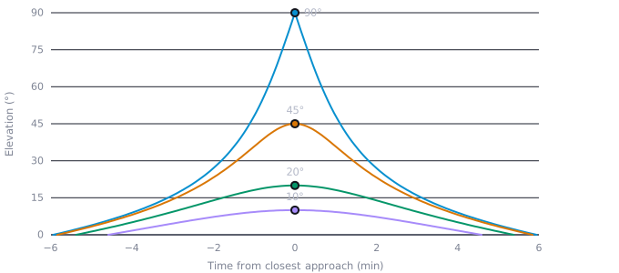
Mid-latitude stations get a few passes in the morning and a few in the evening, separated by gaps of half a day. Polar stations see almost every orbit, which is why commercial networks build them near the poles. The longest pass of a 525 km orbit lasts about 12 minutes above the horizon and 7.7 minutes above a 10° mask.
- Maximum elevation 90°
- Maximum elevation 45°
- Maximum elevation 20°
- Maximum elevation 10°
Show the data as a table
| Time from closest approach (min) | Maximum elevation 90° | Maximum elevation 45° | Maximum elevation 20° | Maximum elevation 10° |
|---|---|---|---|---|
| −6 | — | — | — | — |
| −4 | 9.0 | 8.2 | 5.1 | 1.7 |
| −2 | 27.1 | 23.3 | 14.0 | 7.2 |
| 0 | 90.0 | 45.0 | 20.0 | 10.0 |
| 2 | 27.1 | 23.3 | 14.0 | 7.2 |
| 4 | 9.0 | 8.2 | 5.1 | 1.7 |
| 6 | — | — | — | — |
Doppler and pointing
The carrier shifts by about ±10 kHz at 437 MHz during a pass, fastest at closest approach; directional antennas must also slew fastest then, which limits overhead tracking with slow rotators. The Doppler article quantifies both.
Orbit determination
Ground stations point and tune from two-line elements (TLEs) distributed from the US catalogue. For light, low spacecraft such as PocketQubes, accuracy degrades between updates because drag changes faster than the elements are refreshed[9], which appears as a growing offset in the waterfalls. Fitting the Doppler curves of observed passes refines the orbit and resolves identification after mass deployments[5].
Using open data
A spacecraft that transmits openly decodable telemetry for months leaves a rich public record. The PocketQube review lists the analyses it enables[5]:
- Orbit and identity. Doppler fitting of individual passes refines the orbit and matches signals to catalogue objects.
- Spin rate. The periodicity of signal fading in audio records gives a radio-based proxy for the spin rate, which can be cross-checked against gyroscope telemetry and the predicted passive-magnetic damping.
- Coarse attitude. Panel currents act as coarse Sun sensors; with a bias-calibrated magnetometer[10], two-vector methods yield an attitude estimate.
- Degradation. Long-term trends of panel currents, bus voltages and temperatures quantify the ageing of the power system and the thermal environment.
- Decay. The TLE history together with space-weather indices closes the loop between lifetime forecast and outcome, as the Grizu-263A entry shows.
People and procedures
Operations of an amateur-band mission need licensed operators, a published frequency and frame format, a reliable transmitter shut-down command and a schedule that survives exams and holidays. Pass planning, anomaly procedures and a log of every command belong in a written plan before launch, not after the first silent pass.
References
- [1]White, D. J., Giannelos, I., Zissimatos, A., Kosmas, E., Papadeas, D., Papadeas, P., Papamathaiou, M., Roussos, N., Tsiligiannis, V., & Charitopoulos, I. (2015). SatNOGS: Satellite Networked Open Ground Station. Valparaiso University, Engineering Faculty Publications 40.scholar.valpo.edu
- [2]Libre Space Foundation. (2026). SatNOGS DB — satellite and transmitter database.db.satnogs.org(accessed 20 October 2026)
- [3]Estévez, D. (n.d.). gr-satellites: a GNU Radio out-of-tree module with decoders for amateur satellites.github.com(accessed 20 October 2026)
- [4]Kaitai Project. (n.d.). Kaitai Struct: a declarative language for describing binary data structures.kaitai.io(accessed 20 October 2026)
- [5]nadir lab. (2026). PocketQube-class picosatellites: architecture, flight heritage, and a multi-method post-flight analysis of Grizu-263A [Preprint]. nadir lab. Research Monographs (SQ-R-001).Read on nadir lab.
- [6]Libre Space Foundation. (2026). SatNOGS DB: Grizu-263A (NORAD 51025).db.satnogs.org(accessed 20 October 2026)
- [7]Friis, H. T. (1944). Noise figures of radio receivers. Proceedings of the IRE, 32(7), 419–422.doi:10.1109/JRPROC.1944.232049
- [8]ITU-R. (2026). Recommendation ITU-R P.372-18: Radio noise. International Telecommunication Union.itu.int(accessed 20 October 2026)
- [9]Kahr, E., Montenbruck, O., & O’Keefe, K. (2013). Estimation and analysis of two-line elements for small satellites. Journal of Spacecraft and Rockets, 50, 433–439.doi:10.2514/1.A32352
- [10]Alonso, R., & Shuster, M. D. (2002). Complete linear attitude-independent magnetometer calibration. The Journal of the Astronautical Sciences, 50, 477–490.doi:10.1007/BF03546249
Cite this SatWiki entry
@misc{nadirlab2026ground,
  author       = {{nadir lab.}},
  title        = {{Ground segment}},
  year         = {2026},
  month        = oct,
  howpublished = {nadir lab. SatWiki SQ-OP-002 (Rev. 1)},
  url          = {https://nadirlab.space/wiki/ground-segment/}
}
nadir lab. (2026). Ground segment. nadir lab. SatWiki (SQ-OP-002, Rev. 1). https://nadirlab.space/wiki/ground-segment/
TY  - ENCYC
AU  - nadir lab.
TI  - Ground segment
T2  - nadir lab. SatWiki
PY  - 2026
ET  - Rev. 1
C1  - SQ-OP-002
UR  - https://nadirlab.space/wiki/ground-segment/
ER  -